Datasets:

File size: 3,437 Bytes
05e95cf 9b0c08c 7c42b7c 9b0c08c e42c60a fe84b58 01e16fb fe84b58 01e16fb e42c60a 05e95cf 9b0c08c 7c42b7c 9b0c08c e42c60a 9b0c08c 7c42b7c 9b0c08c e42c60a 7c42b7c e42c60a bf41180 7c42b7c |
1 2 3 4 5 6 7 8 9 10 11 12 13 14 15 16 17 18 19 20 21 22 23 24 25 26 27 28 29 30 31 32 33 34 35 36 37 38 39 40 41 42 43 44 45 46 47 48 49 50 51 52 53 54 55 56 57 58 59 60 61 62 63 64 65 66 67 68 69 |
---
license: cc-by-nd-4.0
task_categories:
- image-segmentation
- image-classification
- image-feature-extraction
- image-to-image
language:
- en
tags:
- agricultural tasks
- Plantations Segmentation
- Object Detection
- image segmentation
dataset_info:
features:
- name: image_id
dtype: int32
- name: image
dtype: image
- name: class_segmentation
dtype: image
- name: object_segmentation
dtype: image
- name: shapes
dtype: string
splits:
- name: train
num_bytes: 48297698
num_examples: 13
download_size: 48362120
dataset_size: 48297698
size_categories:
- 10K<n<100K
---
# Plantations Segmentation Object Detection dataset
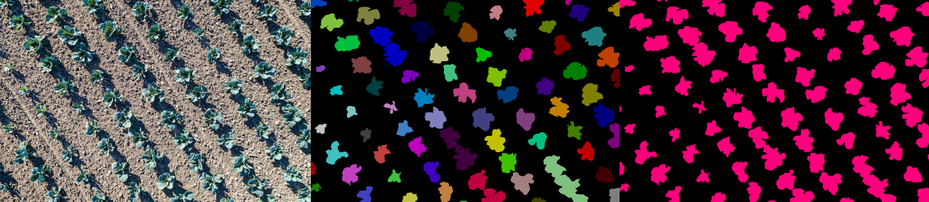
The dataset consist of aerial photography of agricultural plantations with crops such as cabbage and zucchini. The dataset addresses agricultural tasks such as plant detection and counting, health assessment, and irrigation planning.
# 💴 For Commercial Usage: To discuss your requirements, learn about the price and buy the dataset, leave a request on **[our website](https://unidata.pro/datasets/?utm_source=huggingface-td&utm_medium=referral&utm_campaign=plantations_segmentation)** to buy the dataset
# Dataset structure
- **Plantations_Segmentation** - contains of original plantation images (folder **img**) and file with annotations (.xml)
- **Object_Segmentation** - includes object segmentation masks for the original images
- **Class_Segmentation** - includes class segmentation masks for the original images
# Types of segmentation
The dataset includes two types of segmentation:
- **Class Segmentation** - objects corresponding to one class are identified
- **Object Segmentation** - all objects are identified separately
# Data Format
Each image from `img` folder is accompanied by an XML-annotation in the `annotations.xml` file indicating the coordinates of the polygons. For each point, the x and y coordinates are provided.
# Example of XML file structure
.png?generation=1686129907313187&alt=media)
# Plantation segmentation might be made in accordance with your requirements.
# 💴 Buy the Dataset: This is just an example of the data. Leave a request on **[our website](https://unidata.pro/datasets/?utm_source=huggingface-td&utm_medium=referral&utm_campaign=plantations_segmentation)** to discuss your requirements, learn about the price and buy the dataset
Leave a request on [our website](https://unidata.pro/datasets/?utm_source=huggingface-td&utm_medium=referral&utm_campaign=plantations_segmentation) to discuss your requirements, learn about the price and buy the dataset.
## [Our Team](https://unidata.pro/datasets/?utm_source=huggingface-td&utm_medium=referral&utm_campaign=plantations_segmentation) provides high-quality data annotation tailored to your needs
*keywords: agricultural tasks dataset, image segmentation dataset, plantations images dataset, plantations segmentation dataset, land cover dataset, agricultural products dataset, semantic segmentation dataset, agriculture dataset, agricultural data, object detection dataset, plants segmentation dataset, plant detection, plant recognition* |